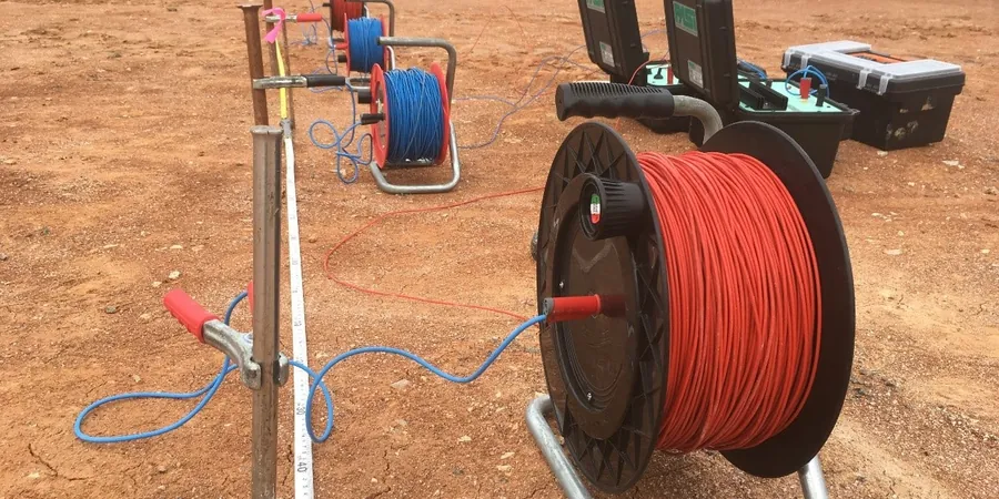
ASTM D6431 outlines the standard practice for using the direct current resistivity method in subsurface investigations. In Hamilton, this standard takes on particular significance. The city sits on the western edge of the Niagara Escarpment, where the sedimentary bedrock—primarily dolostone and shale of the Lockport and Queenston formations—interfaces with thick overburden of glacial till and lacustrine clay. Identifying voids, solution channels, and the depth to competent rock is not a routine check here. It is the foundation of risk management. Our team applies Schlumberger and Wenner array configurations to map these sudden lateral changes. Vertical Electrical Sounding (VES) resolves resistivity contrasts that tell us precisely where competent rock begins and where a weathered zone or clay-filled depression might compromise a footing design. For deeper infrastructure, we often pair the surface resistivity data with seismic refraction to cross-validate the bedrock velocity profile before excavation begins.
A resistivity contrast of 50 ohm-m to 800 ohm-m across a single spread often marks the transition from saturated clay to competent Lockport dolostone in Hamilton.
Methodology applied in Hamilton
Typical technical challenges in Hamilton
Hamilton's variable drift thickness, ranging from a few metres on the mountain brow to over 30 metres in buried valleys near the Red Hill Creek, means that assuming a uniform depth to bedrock is a project risk. A geotechnical borehole tells you what is at one point. A VES sounding tells you what the electrical section looks like between boreholes. In the lower city, we frequently encounter filled channels where the resistivity signature is muted—clay and silt mixed with anthropogenic fill produce a low-resistivity zone that can be mistaken for native soil if only drilling logs are used. The real danger is missing a buried valley or an air-filled cavity in the dolostone caprock. During the 2020 escarpment slope stability assessments, the city's engineering department emphasized the importance of non-invasive methods to avoid triggering further instability in sensitive areas. A resistivity survey run parallel to the escarpment face can detect water-filled fractures before they become a slope failure. For sites within the Niagara Escarpment Plan Area, the data often feeds directly into slope stability analyses where pore-water pressure distribution is a critical input parameter.
Our services
Electrical resistivity surveys in Hamilton are configured to address three principal investigation targets: bedrock topography mapping, karst feature detection, and groundwater exploration. Each service includes field acquisition, data processing with least-squares inversion, and a final report containing resistivity pseudosections and interpreted geoelectric layers.
Bedrock Profiling and Overburden Thickness
VES soundings along planned alignment corridors to map the depth to the top of the Lockport or Queenston formation. Used for pre-excavation planning and deep foundation design where borehole spacing exceeds 30 m.
Karst and Void Detection Surveys
Grid-based resistivity profiling with Wenner array to identify air-filled or clay-filled cavities within the dolostone caprock. Applied along the escarpment brow and in areas with historical subsidence records.
Groundwater and Plume Delineation
Resistivity sections oriented perpendicular to groundwater flow direction to map leachate plumes or saline intrusion in the overburden aquifers beneath the industrial waterfront.
Frequently asked questions
How much does a VES survey cost for a standard site in Hamilton?
For a typical investigation in the Hamilton area involving four to six VES soundings with Schlumberger array and 1D inversion, the cost ranges from CA$860 to CA$1,320 per sounding. The total depends on access conditions, line clearance requirements, and whether we need to integrate the data with existing borehole logs.
What depth can a VES survey reach in the Hamilton escarpment area?
The maximum depth of investigation is controlled by the current electrode spacing (A/2). With a practical maximum A/2 of 150 metres, we can resolve resistivity layers to depths of 60 to 100 metres. In Hamilton, this is sufficient to penetrate the entire overburden sequence and enter the competent Lockport dolostone, even in the deepest buried valleys near the Red Hill Creek.
How does electrical resistivity complement borehole drilling on Hamilton sites?
Boreholes provide discrete data points. A VES survey provides continuous vertical information along a profile line. By running resistivity lines between borehole locations, we can interpolate the bedrock surface and identify anomalies—such as a clay-filled depression or a fractured zone—that a drilling program with wide spacing might miss. The borehole log then serves as a ground-truth calibration for the geophysical model.