A project in the lower city near Barton Street and one up on the Mountain brow near Limeridge Road can produce completely different shear wave velocity profiles, even with the same overburden thickness. Hamilton's geological contrast between the deep glaciolacustrine clays of the former Lake Iroquois plain and the fractured dolostone caprock of the Niagara Escarpment means a generic site class assumption rarely holds. An MASW survey gives you the measured Vs30 value needed to lock in your NBCC 2020 site classification, replacing the conservative default that often inflates seismic design loads. When you pair that with a seismic refraction line, you can simultaneously map bedrock depth and rippability across the parcel, which is especially useful on the escarpment slopes where rockhead can vary by several meters over a short distance.
A measured Vs30 can drop a Hamilton site from NBCC Site Class E to D, directly reducing the design spectral acceleration by 20 to 30 percent.
Methodology applied in Hamilton
Typical technical challenges in Hamilton
On Hamilton's lakeshore plain, we often see sites mapped as Site Class E on regional screening maps when a proper MASW survey would return a Class D or even C profile once you account for the stiff Halton Till at depth. Relying on the mapped default without a measured Vs30 can easily push a mid-rise building into a higher seismic force category under NBCC, adding unnecessary reinforcement and detailing requirements. The opposite problem shows up on the escarpment: fractured dolostone can produce a lower effective shear wave velocity than intact rock, and if you assume a hard rock site class without measuring, you risk underestimating the ground motion. A single MASW line across the foundation footprint, processed with a fundamental-mode inversion validated against at least one borehole log, eliminates both scenarios. The cost of the survey is trivial compared to the potential overdesign or the liability of an unconservative site classification.
Our services
Each Hamilton project lands on a different geological unit, so the MASW deployment adapts to the site constraints and what the structural engineer actually needs from the ground model. The four configurations below cover most Ontario Building Code requirements.
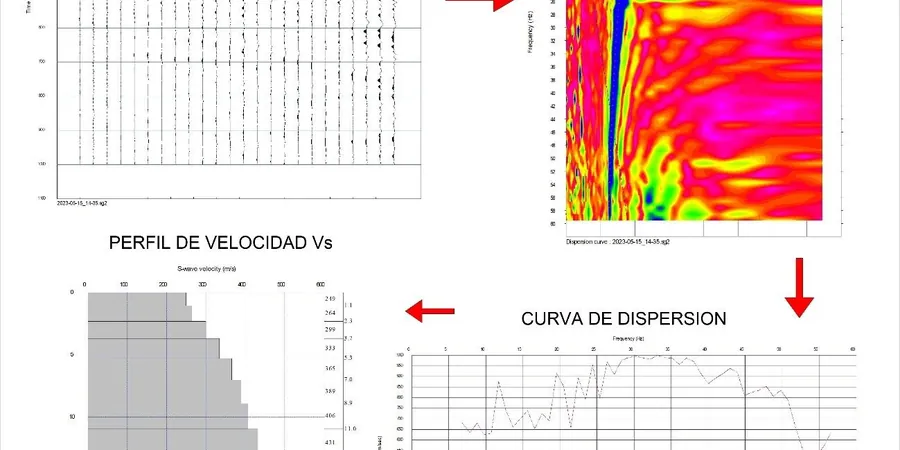
Full Vs30 Site Classification Survey
Single or multiple MASW lines to determine NBCC site class (A through E). Includes 1D Vs profile, Vs30 calculation, and a letter report signed by a professional engineer licensed in Ontario.
2D Shear Wave Velocity Cross-Section
Roll-along MASW acquisition along a profile with overlapping spreads, producing a continuous Vs cross-section to 30 m depth. Used for mapping lateral changes in stiffness across a building footprint or along a slope.
Combined MASW & Seismic Refraction
Same receiver spread, two source types — sledgehammer for surface waves, heavier impact for P-wave refraction. Delivers Vs30 plus bedrock depth and rippability in one mobilization, ideal for escarpment sites with variable rockhead.
Downhole Seismic Verification
Downhole Vs measurement in a cased borehole, triggered at 1 m intervals, correlated with the MASW dispersion curve. Provides a site-specific ground truth for critical structures where regulatory review requires borehole-based velocity data.
Frequently asked questions
How long does an MASW survey take on a typical Hamilton infill lot?
For a residential or small commercial lot, one or two MASW lines can be acquired in half a day. The dispersion analysis and inversion to a 1D Vs profile usually takes another day in the office, so you can have a draft Vs30 value within 48 hours of field completion.
Can MASW work on paved sites like a parking lot in downtown Hamilton?
Yes, it works well. We use geophones with steel base plates that couple to asphalt or concrete, and the sledgehammer source generates enough energy through the pavement. The main consideration is traffic control if the area is active — we schedule around off-peak hours.
What does an MASW survey cost for a single-family home lot in Hamilton?
For a standard Vs30 determination on a residential lot, you are looking at a range of CA$1.960 to CA$4.030 depending on the number of lines, access conditions, and whether we combine it with a refraction survey. A fixed-price proposal comes out once we see the site plan and the building footprint.
How does NBCC 2020 use the Vs30 you provide?
NBCC 2020 classifies sites from A (hard rock, Vs30 > 1500 m/s) to E (soft soil, Vs30 < 180 m/s) based on the average shear wave velocity in the top 30 meters. The site class determines the short-period and 1-second site coefficients that scale the design spectral acceleration, so a measured Vs30 ties directly into the seismic base shear calculation for the structure.